FINDING LOCAL TIME WITHOUT COMPASS
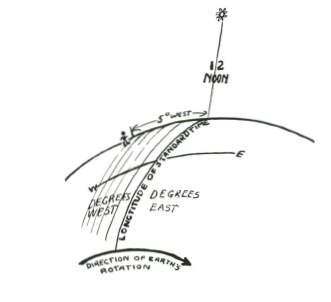
It is apparent that if you can find North-south by the method given from the shadow of the stick that you can then work out the number of degrees the sun is off the North-south line and thereby discover the correct local time, provided you know the longtitude of standard time, and the longtitude of your position.
THE SUN’S PATH THROUGH THE SKY, AND TO FIND THE SUN’S HEIGHT IN THE SKY FOR ANY PERIOD
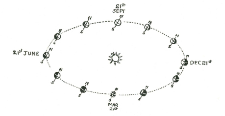
To be able to accurately measure the sun’s path along the sky you must know how high it is at its highest point (Zenith), and to find this out, you should be able to discover the sun’s position North or South of the Equator for any day of the year.
This position of the sun is called ‘Declination.’ As you know, the sun is farthest North on June 21st, crosses the Equator September 21st, farthest South December 21st and recrosses the Equator on its way North on March 21st. This is caused by the inclined angle of the axis of the earth in relation to its path round the sun.
TO FIND THE SUN’S POSITION NORTH OR SOUTH OF THE EQUATOR
The degree, or slope of the inclined path is approximately 23½ degrees, so that when the sun is farthest North it is overhead 23½ degrees North of the Equator, and when farthest South it is overhead 23½ degrees South of the Equator.
It is possible to work a circle of ‘Declination’ showing you the path of the earth round the sun, and the reason.
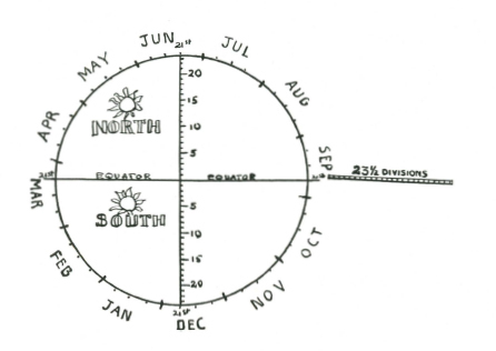
You can draw this diagram on the ground. Take a straight stick and cut 23½ divisions along its length. The size of the divisions must be absolutely equal.
If you use the width of your knife blade, or some equally simple measure, it will serve. With this stick as a radius, draw a circle on the ground, and divide the circle into four quarters with straight lines that cross the centre of the circle.
Now divide each quarter of the circumference of-the circle into three equal divisions. Mark these June, December, March and September as shown. Now divide each month into four smaller equal divisions. These represent the four weeks of the average month.
Draw a thick line from the start of the fourth division of June to the start of the fourth division of December, and from the start of the fourth Division of September to the start of fourth division of March.
These lines should intersect each other in the centre of the circle. The lines from June to December represent the North-south line, and the line from March to September the Equator.
For any day of the year find the approximate day on the outer circle and draw a line parallel to the Equator line to the North-south line, and then simply measure off with your stick the number of nicks from the Equator line, starting in the centre, to the date line. If the sun is on the June side of the Equator line it is North of the Equator: if on the December side it is South.
You should be accurate to within a quarter degree. This accuracy is needed for latitude work, but not necessary for the Sun Clock.
THE SUN’S HEIGHT ABOVE THE HORIZON
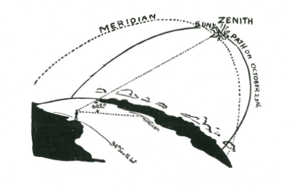
To the sun’s declination you must make an allowance for your own latitude. For instance, if you are in latitude 42° North, and the date is April 21st, the sun will be 12° North, which means that at its zenith it will be 60° above the horizon. To work this out subtract your Latitude from 90°, and add the sun’s declination. If the sun is on the other side of the Equator, subtract the declination.
METHODS OF OBTAINING ELEVATION OF SUN AND STARS
Latitude: A degree of longitude on the Equator equals 60 nautical miles; therefore 1 minute equals 1 nautical mile.
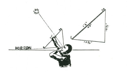
The elevation or height above the horizon of the sun or stars can be obtained by means of a plumb-bob quadrant-or, as Harold Gatty calls it in his ‘Raft Book,’ a Harp. The quadrant harp is made with two pieces of cord, and a straight piece of wood. The dimensions of both cord and wood MUST be accurate. The wood should be straight and smooth, and not less than eighteen inches long. Both ends should be flattened and a hole bored or burnt through the flattened ends. The holes should be exactly eighteen inches apart on their inside edges.
Through these two holes, two lengths of cord are passed, with a thumb knot to hold them fast. Two pieces of cord are tied together at almost exactly 12¾ inches (or if 36 board–string must be 25.45 inches) and where they are joined a third thinner length of cord for the plumb-bob is also tied so that it swings from the joining of the two cords of the harp. This plumb-bob cord should be about eighteen inches long. To the lower ends a weight such as a clasp knife or lead sinker, or a long thin stone is tied.
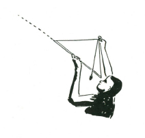
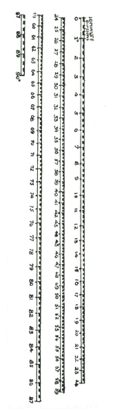
From the inside edge on one hole you mark off nine inches on an eighteen-inch harp or eighteen inches on a thirty-six-inch harp, and again a second mark an equal distance from the other end. The two parts should meet exactly in the centre of the stick. On one side of the stick along the nine-inch (or 18" side) side you mark the scale given in the margin. This scale is shown in short lengths for convenience, but for the marking on the stick you should read it as one scale. From 0 to 45° reads along one side on the stick and 45° to 90° along the other side, or alternatively you can mark the stick continuously from end to end. To use the 'Harp,' sight upwards along the cord at the 90n end till the cord is aligned with the sun or star. The plumb-bob should be swinging almost free along the stick, and when the cord is aligned the plumb-bob string will just brush against the number of degrees of elevation of the sun or star observed. You can get a reading accurate to ½ degree or less with this 'Harp.'
For finer readings–make the base stick 36”, the cord 25.45” and make each degree on the scale twice as long.
(Readers interested are Book’ by Harold Gatty.) recommended to study ‘The Raft Book’ by Harold Gatty.)
IMPROVISED QUADRANT
Another method of obtaining elevation of a heavenly body is by means of an improvised quadrant, over a puddle of water, the surface of which serves as an accurate ‘horizon.’
A useful measurement to remember is that a degree very nearly equals one inch on the circumference of a circle of a radius of fifty-seven inches.
A straight stick is marked off into 57 divisions of equal length. The actual length of each division is not important but the divisions must be as regular as possible. Another whippy length of cane or very pliable stick is marked off into divisions of the same length. These can be marked at five or ten division intervals to save work, but a smaller stick should be marked off into separate divisions for accurate reading between the five or ten division marks.
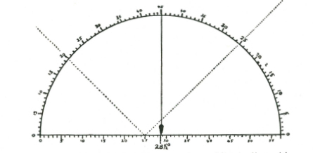
The straight stick is laid across the puddle, in line with the heavenly body to be measured, and the end of the ninety division stick is pushed into the ground so that the first mark is just level with the water surface. The stick or cane is bent right over till the other end comes to the other end of the fifty-seven division stick, and it too is pushed into the soft dirt beneath the water. The ninety division stick is then bent by hand until it assumes the shape of a semi-circle.