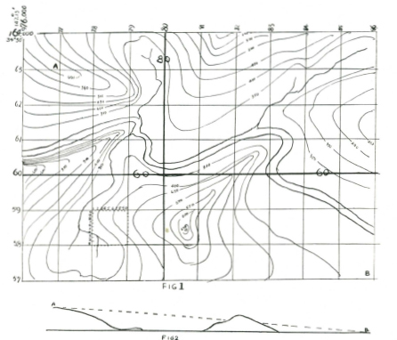
Contour lines are imaginary lines parallel in height and with an equal height separating one height line from the next. By correctly reading contours on a map you can tell if one hill is convex or concave in its slope. If concave, you can see the bottom of the hill from the top, unless of course intervening vegetation limits your visibility. With convex slopes you cannot see the lower grades because the curvature of the slope cuts off your field of vision.
The end of the spur in top left position of the map shown is a convex slope, and the slope east from the hill bottom centre is a concave slope.
A convex slope shows the contour lines closer together at the foot of the hill, and wider apart at the top, while a concave slope shows the contour lines farther apart toward the lower slopes.
Position on a map is always given by a ‘map reference.’ These are a series of numbers which indicate the square referred to. You will see in the top left corner of the map (Fig. 1) numbers reading vertically and also other numbers reading horizontally. These numbers are always shown on military maps, which you are more likely to use than others.
The vertical figures indicate the longitude (shown as 147 degrees 15 minutes), and the other figures 976,000 are the number of yards from the 'base line' of that section of country. Reading to the right from the top left corner each smaller square is indicated by the last two THOUSAND numbers, 77, 78, etc. Each square is 1000 yards (unless marked otherwise—see the map scale for this information). The same rule applies to the horizontal numbering; on this column is shown the latitude of the line (in this case 34 degrees 50 minutes south of the equator). Map references are read from west to east first and from south to north, so that the figures 78.58 mean that you look along the grid line 78 until you find the square starting 58, and the reference is within that 1000 yard square. Each thousand yard square is divided again into ten smaller squares, each of which is 100 yards. This gives a six-figure reference 782.583. and you will find that this is the fork of the creek in the third square second row from the bottom.
Now see if 806.584 is the top of a hill?
Map reading when done correctly allows you to build up in your mind a picture of what you could see from any given position. If you were on the spur at A 768.632, could you see the position B at 858.572? In the lower diagram (fig. 2) the elevations between A and B have been plotted. The tongue of hill running north-east through 81.59 and 82.60 would interrupt your view of B from A.
A military map also shows you a ‘legend,’ which are symbols indicating vegetation, water, and roads, etc. This is generally given at the foot of the map, and assists you in building up in your mind a complete picture of the country.
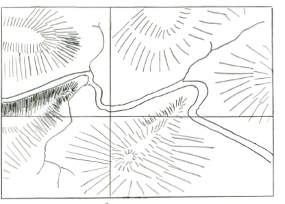
Hatchuring, instead of contour lines, is used by some map makers to give an indication of the nature of the country. Fig. 3 would be a hatchured map of the same country shown in fig. 1. In hatchuring thick strokes close together indicate very steep grades, while thin strokes far apart indicate gentle slopes. In many European maps the hatchurings are definite, thick strokes very close together might mean a slope of 1 in 2, to 1 in 3; thick strokes farther apart a slope of 1 in 4 to 1 in 6; thin strokes close together 1 in 8 to 1 in 10. These of course may be also expressed in degree of slope (1 in 56 grade equals a one degree slope).
THE SUN COMPASS - SUN CLOCK
Direction and time can both be obtained by drawing a sun compass - sun clock on your map. Trace off overleaf for the latitude line nearest to your map, and it will be both a compass and a clock for you. With a sun compass - sun clock, when you have any one of the following you can discover the other two.
1. A watch to get correct time.
2. A reliable compass.
3. A map correctly oriented (that is laid in the ground so that the features drawn on the map correspond exactly with the recognisable ground features).
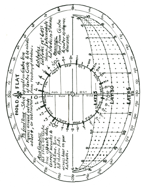
WHEN YOU ARE ABLE TO ORIENT YOUR MAP CORRECTLY
The north-south line of your sun compass will correspond with the north-south of your map, and your time is read and corrected as explained in the preceding instructions.
To orient your map select two, or better, three, recognisable land features, and identify these on your map. Turn your map until the identified features exactly correspond in direction with the ground features. When this is done your map should exactly fit all the ground plan visible from your position.
WHEN YOU HAVE A WATCH SET TO CORRECT TIME
Place a thin shadow stick on the centre line of the sun compass which must be held flat, opposite the appropriate date, and turn the map until the shadow falls across the adjusted time on the latitude line.
When you have done this your map will be set to TRUE north, and oriented with the ground features.
WHEN YOU HAVE A COMPASS
Place your compass on the map with its axis along TRUE north line, and turn both map and compass till the compass needle is pointing to the MAGNETIC north of your map. (This may be east or west of TRUE north depending where you are.) The magnetic variation is shown on ALL Ordinance Survey (Military) maps.
When you have done this, hold the shadow stick on the north-south line of the sun clock opposite the appropriate date and where the shadow of the stick falls across the latitude line is local sun time. To correct to STANDARD or CLOCK time make the correction for the equation of time shown opposite the date, and also the correction for longitude by deducting four minutes for each degree you are east of the longitude of standard time, or adding four minutes for each degree you are west. (When east of the longitude or standard time the sun is earlier, and when west the sun is later.)
When the magnetic of your compass exactly points to the magnetic north of your map, then your map is correctly oriented.
WEATHER LORE
An infallible weather forecast, if a change of weather is coming up, is in the nautical couplet:
“When the rain is before the wind, your topsail halyards better mind,
But when the wind is before the rain, then hoist your topsails up again.”
In plain words this says that when rain comes first without wind then expect a long period of bad weather with high winds and heavy rain. But when wind comes first and is followed immediately by rain, then fine weather will follow at short notice.
Many people are trapped by bad weather in the bush every year, and if they but knew of this simple weather sign they could be prepared, and get out to a position of safety before really bad weather sets in.
Another infallible weather signal is the appearance of cumulus nimbus cloud, a foreteller of thunderstorms. While a greenish light in the sky preceding a thunderstorm is an almost certain sign of heavy hail.
CLOUDS AND THEIR READING
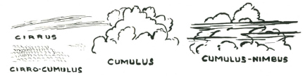
Cirrus, this is the “mare’s tail” sky of the landsman, shows as long threads or wisps of cloud. This is the highest of all cloud formations, and is a sign of a “high” barometrical pressure, which means fine weather.
Cirro Stratus, and Cirro Cumulus. In these clouds the former is long wispy cloud, and in the latter rounded small cloud the typical “mackerel” sky. Both are indicators of a high barometric pressure, and fine weather.
Cumulus and Cumulus Nimbus. Cumulus is the high white piled-up masses of cloud seen in summer. When streaked with horizontal bands it is Cumulus Nimbus, or thunder cloud, a sign of coming storms, which may be of short duration, or may indicate a change in the weather generally.