TIME FROM THE SUN WITH COMPASS
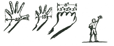
A means of measuring degrees–arms must be fully extended.
Hand at full arm’s length, fingers widely spread 22 degrees
Thumb turned in . . . . . . . . . . . . . . . . . . . 15 degrees
Closed fist . . . . . . . . . . . . . . . . . . . . . 8 degrees
From second knuckle to edge of fist . . . . 3 degrees
Between two centre knuckles . . . . . . . . 2 degrees
These vary slightly like your personal dimensions and for accuracy should be accurately checked by each individual with a compass.
By this means, if you have a compass, time can be easily read from the sun’s position. This should be possible to within four or five minutes. Decide from your compass your true North-south line and remember to make allowance for the magnetic variation from True North. Measure the number of degrees the sun is from this imaginary line, and multiply the number of degrees by four to obtain the number of minutes.
For example:
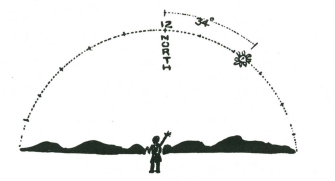
Here the sun is 34 degrees from the North-south line. It is morning, because the sun is on the eastern side of the North-south line, 34 x 4 = 136 minutes before noon; therefore it is sixteen minutes to ten in the morning local sun time.
This does not mean that it will be 16 minutes to ten by the local clock, because there are two corrections to be made before local standard (or clock) time can be determined. These two corrections are dealt with under the headings of EQUATION OF TIME, and LONGITUDE CORRECTIONS.
It is sufficient for the moment that you can measure time accurately from the sun.
ACCURATE DIRECTION FROM SUN WITH A WATCH
The method of obtaining direction from a watch by pointing the hour hand (or ‘twelve o’clock’ depending upon which hemisphere you live in) is not accurate, but only approximate.
The accurate method, knowing the time, is to calculate the number of degrees changed to minutes in time, before or after noon, and then to measure from the sun’s position along the curved path of the sun through the sky. Even if you make no allowance for the two corrections (see section Equation of Time and Longitude Corrections of Time pages 326, 328), you will be accurate within five to eight degrees and if you make the two corrections for time you will be accurate to less than one degree.
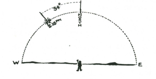
Example: It is 2.16 p.m. by your watch, therefore the sun is to the west of the North-south line. 2.16 p.m. means that the sun has travelled 136 minutes of time past the North-south line. It travels one degree along its curved path in the sky every four minutes of time, so that it is 34 degrees along its path past noon. Measure this back along the sun’s path and you will have true North. (For Northern Hemisphere read South for North and reverse all other cardinal points.)
CARDINAL POINTS AND BEARINGS
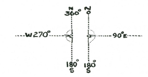
Having found the true North, you can find any bearing from true North very easily and within five degrees of error. If the bearing you want is less than 180°, face East, and stretch out your left arm to true North. Raise your right arm along your side till there is a perfectly straight line along both arms. Your right arm is now pointing to South or 180 degrees True. Bring the two arms together evenly, and you are pointing to East or 90 degrees True, and you can then measure the number of degrees from these cardinal points to the bearing you require. By facing West, and pointing your right arm to the North and your left to South you can get bearings greater than 180 degrees.
FINDING NORTH-SOUTH LINE WITHOUT COMPASS OR WATCH
Knowing that the sun is at its highest point in the sky at midday, and that this point is on the North-south line means that by finding where this position will be, will give you true North.
You can do this by measuring the points of shadow made by the top of a fixed stake. These points of shadow may give you a curved line either concave or convex to the stake. Continue the curve made by the points of shadow, and then draw a circle on the ground round the base of the stake. Where the curved line cuts the circle will be accurate East and West, and a right angle from these two points will be an accurate North and South line.
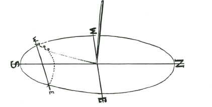
Here you see the stake, and points of shadow recorded over an hour in the morning. The dotted line is a continuation of the curve made by the points, and the intersection of this curved line with the circle gives you East and West. If North of the Equator the cardinal points will be reversed.
This Shadow-stick method is very accurate, if done over a period of an hour or two.
EAST-WEST LINE—During Equinoctial Periods
You will find from the foregoing that it is actually easier to find the true East-west line than the North-south. The idea of always working from, or to, North is largely conventional. The top of every map is assumed, unless marked otherwise, to be North. All bearings are measured clockwise from true North, but in actual practice it is often easier to find one or other of the cardinal points, rather than concentrate on finding the North Point. An instance is the ease with which the East-West line can be discovered.
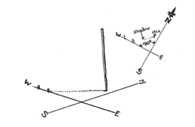
There are two days in the year when the points of shadow will form an accurate East-west line throughout the whole day. These two days are the 21st March, and the 21st September, the days when the sun is over the Equator. On these two days the sun is at right angles to the axis of the earth, and therefore directly over the Equator, and no matter where you are on the earth’s surface the shadows will move true East and West on these two days. Because of this if you mark a point of shadow by putting a peg into the ground, and then, five minutes later, mark the new position of the same shadow you will have a perfect East-West line. For general purposes if less than 40° North or South latitude this method will serve you for about two or three weeks either side of the Equinoctial periods with reasonable accuracy, so that on any day between March 1st and April 14th or September 1st and October 14th you can assume that the shadow line is very nearly a true East-west line. At all other periods or when you want greater accuracy you will have to work out the curve and extend it to the edges of the circle as in the preceding section.
The points of shadow move accurately true East and West on March 21st and September 21st.
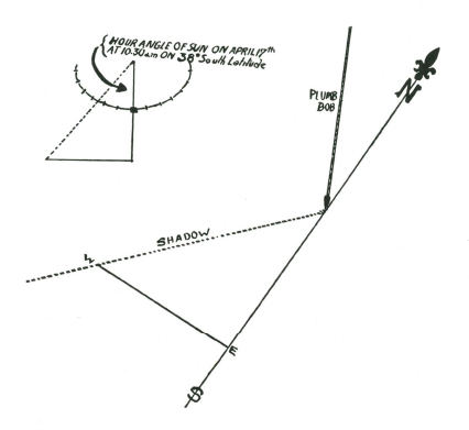
An extremely accurate method of finding true North is to work out the hour angle of the sun and transfer this hour angle to the shadow thrown onto the ground from the string of a plumb bob.
To find the hour angle, use the method given in the section on the sun compass and extend from the shadow of the stick, the hour angle correct for your Latitude and date.
The sun compass diagram does not require to be set correctly to work out the hour angle. Any direction will serve for the imaginary North-south line.
When the triangle has been worked out, a corresponding triangle is made on the correct side of the shadow from the cord of the plumb bob.
You should work out the hour angle on the sun compass on the ground about fifteen minutes ahead of the watch time, so that when you have worked on the diagram and made the necessary time and longitude corrections, you will be able to plot the hour angle at precisely the right moment on the shadow. This method, if done accurately and corrections of time for longitude and Equation worked out, should be correct to within less than a quarter of a degree, or one minute of time.