The use of type loads does not limit the flexibility of a ground tactical unit to be airlifted. The type-load method is very useful at battalion and company levels to plan and conduct air assault operations. Your supporting aviation unit will supply you with necessary load and type-load planning information.
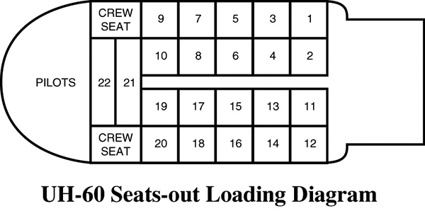
Seats-Out Operation
With the UH-60, if the troop seats are removed, twenty-two combat-loaded soldiers and their rucksacks can be loaded (this is contingent on area-specific equipment such as armor, water, etc). Conducting combat operations with seats out reduces the number of aircraft needed for each mission. The aircraft can be loaded from either or both sides. Loading is quicker if both sides are used. Before the soldiers enter the aircraft, each soldier’s rucksack is placed on the floor of the aircraft where the soldier will sit. Once all rucksacks are in, the soldiers are loaded from rear to front. Soldiers in the aircraft help by pulling the others in tightly until they are all on board and the doors are closed. The aircraft doors should be opened as the helicopter approaches the LZ. Soldiers hold on to each other until time to unload. They should unload from both sides if the ground slope permits. (Caution: The seats-out technique is used in combat only—never in training.)
AREA SECURITY OPERATIONS
Area security operations protect specific critical and vulnerable assets or terrain from enemy observation and direct fire. These operations can consist of escorting friendly convoys (with an augmentation of vehicles); protecting critical points such as bridges, C2 installations, or other key and vulnerable sites; or participating in protection of large areas such as airfields. During stability or support operations, the platoon may be required to establish OPs, roadblocks, or checkpoints. The platoon normally performs an area security operation when conventional security or combat operations would not work, and does so independently or as part of a larger force. Infantry platoons normally conduct area security missions to protect high-value points, areas, or assets. Whether these need protection, how much protection they require, and the defensive technique chosen to protect them depends on the factors of METT-TC. The platoon leader must integrate his elements into the overall security plan for the area he must protect. Area security operations rely on various techniques, which may include reconnaissance, security, defensive tasks, and offensive tasks.
CONVOY AND ROUTE SECURITY
Company and larger organizations usually perform convoy or route security missions. Convoy security provides protection for a specific convoy. Route security aims at securing a specific route for a designated period of time, during which multiple convoys may use the route. These missions include tasks such as escorting, reconnaissance, and establishing a combat reaction force. These tasks become missions for subordinate units. The size of the unit performing a convoy or route security operation depends on many factors, including the size of the convoy, the terrain, and the length of the route.
Vehicles
In order for an infantry platoon to conduct convoy or route security, it must be augmented with vehicles. Vehicles should include up-armored vehicles. There are numerous types of armored vehicles in the inventory. What is most important is that drivers are knowledgeable and well trained for combat operations. Second, the vehicles used in combat need to be the same vehicles used in rehearsals. This will ensure that combat drills are executed swiftly and correctly.
Route Reconnaissance. In this mission, the platoon leader focuses on the route’s trafficability and on enemy forces that might influence the route. Below is an example of a movement route survey.
MOVEMENT ROUTE SURVEY—PRIMARY, ALTERNATE, VARIANT, AND EMERGENCY
Code name _____________________________________________
Primary/alternate _____________________________________________
Maps/charts: area _____________________________________________
Maps/imagery: neighborhood _____________________________________________
Road surface: condition, construction _____________________________________________
Weather concerns: difficult, impassable _____________________________________________
Chokepoints/danger areas: (i.e. checkpoint survey) _____________________________________________
Dead-end/one-way streets: location, markings _____________________________________________
Major turns: _____________________________________________
Landmarks: local name, code name, grid _____________________________________________
Possible attack points along route: demeanor of persons in area _____________________________________________
Historic attack points _____________________________________________
Enemy TTP in the area: IED, gunfire _____________________________________________
Evasion possibilities _____________________________________________
Cameras along route: police, military _____________________________________________
Location of hospitals: level of care, hours of operation _____________________________________________
Location of hard points/Alamo: along route, close to route _____________________________________________
Location of safe haven: friendlies (military, police, UN, NGO) _____________________________________________
Distance _____________________________________________
Traffic conditions: time of day, day of week _____________________________________________
Travel time: time of day dependent, rush hour _____________________________________________
Natural flow of traffic: rush hour _____________________________________________
Local customs: right- or left-side drive, horn _____________________________________________
Conflicting events or holidays that will impact the movement _____________________________________________
Pedestrian traffic: time of day, day of week _____________________________________________
Timeline _____________________________________________
Checkpoint/Chokepoint/Roadblock Reconnaissance. The leader needs to know certain pieces of information so that checkpoints, chokepoints, and roadblocks can be navigated with as little disruption to the mission as possible. Below is an example of a checkpoint survey.
CHOKEPOINT/CHECKPOINT/ROADBLOCK SURVEY
Code name _____________________________________________
Location: grid/map _____________________________________________
GRG: series/number and pictures/imagery _____________________________________________
Barrier type: construction/materials _____________________________________________
Barrier layout _____________________________________________
Historical: attack point/riot point/demonstration point (intelligence) _____________________________________________
What elements/unit guarding _____________________________________________
Number: military/police/militia _____________________________________________
Uniform or civilian clothes _____________________________________________
Disposition of guards (alert, trained, bored, etc.) _____________________________________________
Guards known for corruption? _____________________________________________
What are the procedures to pass (ID, placards, pre-coordination, etc _____________________________________________
_____________________________________________
TTP used to pass chokepoint (bounding, speed, etc.) _____________________________________________