NATIONAL ANTHEM
The old Tibetan national anthem or national hymn, Gangri Rawae or “Snow Mountain Ramparts” [20] was composed in 1745 by the (secular) Tibetan ruler Pholanas. [21] It was recited at the end of official ceremonies and sung at the beginning of opera performances in Lhasa. [22]
When the Tibetan government came into exile in India, a more modern national anthem, Sishe Pende [23] (“Universal Peace and Benefits”) was adopted. The lyrics were composed by the Dalai Lama’s tutor, Trichang Rimpoche, who was considered a great poet in the classical nyengak (Skt. kaviya) tradition.
MAPS OF TIBET
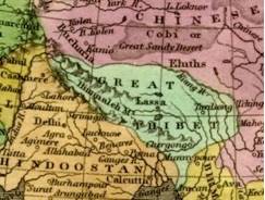
Detail from 1827 map [24]
Most pre-1950 maps, globes and atlases, including the earliest maps on record of Asia, depict Tibet as an independent nation, separate from China. Tibet is variously referred to as Tobbat, Thibbet or Barantola. A map of Asia drawn by the Dutch cartographer, Pietar van der Aa around 1680 shows Tibet in two parts but distinct from China; [25] as does a 1700 map drawn by the French cartographer Guillaume de L’isle, where Tibet is referred to as the “Kingdom of Grand Tibet.” [26] A map of India, China and Tibet published in the USA in 1877 represents Tibet as distinct from the two other nations. [27] An 1827 map of Asia drawn by Anthony Finley of Philadelphia, clearly shows “Great Thibet” as distinct from the Chinese Empire. [28]
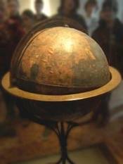
Martin Behaim’s globe at Nuremburg
The oldest existing globe in the world, and possibly the first terrestrial globe ever made, was constructed by Martin Behaim (geographer to the king of Portugal) in 1492. It depicts the world before the discovery of the Americas. Tibet is clearly identified in German as “Thebet ein konigreich”, or “ Tibet, a kingdom”. [29]
The largest stained glass globe in the world (in Boston), based on the Rand McNally 1934 map of the world, shows Tibet as a separate nation. [30]
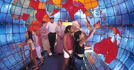
The “Mapparium” in Boston, MA.
Early Chinese maps do not feature Tibet as a part of China. In a landmark map of China [31] drawn in 1594 by Wang Fen (or Wang Pan?), a senior Ming Legal Officer, there is a note stating that the map included the whole of China ’s territory. But no Tibetan areas, not even the eastern-most regions of Amdo or Kham, appear on the map.
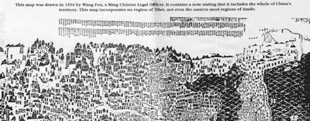
Upper section of 1594 Ming Map
Following the publication of the atlas commissioned by the Manchu Emperor Kangxi and created by French Jesuit cartographers, some Chinese and European maps begin to depict Tibet as a colony or protectorate of China. The Jesuits could not personally survey Tibet (as they had surveyed China and Manchuria), since Tibet was not part of the Chinese Empire. So they trained two Mongol monks [32] in Beijing and sent them to make a secret survey of Tibet. Similar clandestine surveys of Tibet were conducted by British mapmakers using trained Himalayan natives and even a Mongol monk. An American sinologist, writing on such issues, notes that, like European colonial powers, China used cartography to further its “Colonial Enterprise” in Tibet and Korea. [33]
TIBETAN CURRENCY
Literary sources [34] refer to gold, silver and copper ingot-coins, even cowrie shells, being used as currency in ancient Tibet. From circa 1650 silver coins for Tibet (the Bhal-tang) were struck in Nepal under a treaty agreement. [35] In 1792 following the defeat of Nepal by a joint Tibetan-Manchu force, coins bearing both Tibetan and Chinese inscriptions were circulated. But the Tibetan government continued to issue its own coin with only Tibetan legends as the Kongpar tangka (1791-93) and the Gaden tangka (1836-1911). A silver coin, the Kalsang tangka, was struck in 1909 possibly to mark the 13th Dalai Lama’s return to Lhasa from Peking.
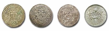
Kongpar tangka, Gaden tangka, Kalsang tangka and three Srang coin
After the expulsion of the Chinese army in 1912, Tibet minted gold, silver and copper coins (in the “srang” currency unit) using Buddhist and Tibetan designs and bearing the name of the Tibetan government. Paper currency was introduced into Tibet in the early 20th century, and according to the numismatist Wolfgang Bertsch, these bank notes were “small works of art.” [36] A unique aspect of Tibetan banknotes was that the serial numbers were handwritten by a guild of specialist calligraphists, the “epa”, to prevent forgery.
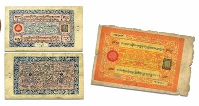
Even after the Communist invasion, Tibetans successfully resisted Chinese efforts to take over its currency. Official Chinese currency only came into use after the flight of the Dalai Lama and the Tibetan government from Tibet in March 1959. [37] In its entire history, official Chinese currency had never been used in Tibet before 1959.
TIBETAN PASSPORTS
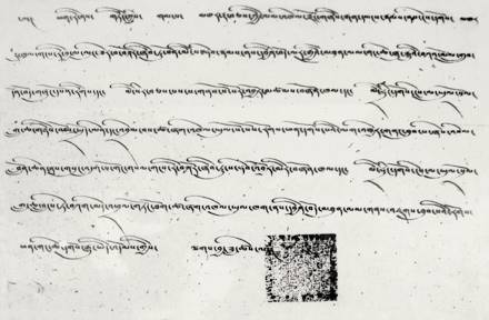
The Tibetan government issued its own passports to travelers entering its borders or (the few) Tibetans who traveled abroad. Before WWII, the term “passport” covered visas and travel documents in general. The earliest record of a Tibetan passport issued to a foreign traveler is in 1688 to an Armenian merchant, Hovannes (Johannes). [38] In 1780 a passport was issued from Lhasa [39] to Purangir Gossain, an emissary of the Governor-General of India, Warren Hastings, who hoped to open up Tibet to trade with the East India Company.
Passport issued to first Everest Expedition, 1921 (courtesy of Rinchen Dorjay).
The Tibetan government gave its approval for the first-ever Everest expedition in 1921. Charles Bell, the visiting British diplomat in Lhasa wrote “I received from the Tibetan Government a passport in official form, which granted permission for the climbing of Mount Everest.” [40] The subsequent Everest expeditions of 1924 and 1936 [41] also received passports from the Tibetan government. Passports were sometimes issued for scientific undertakings: the Schaeffer anthropological expedition of 1939, [42] Tucci’s ethnological expedition of 1949 [43] and the plant hunter Frank Kingdon Ward in 1924. [44]
[20] OLD TIBETAN NATIONAL HYMN
Ghang ri rawe kor we shingkham di
Phen thang dewa ma loe jungwae ne
Chenrezig wa Kalsang Gyatso yin
Shelpal se thae bhardu
Ten gyur chik
Circled by ramparts of snow-mountains – this sacred realm,
This wellspring of all benefits and happiness.
Kalsang Gyatso, bodhisattva of compassion
May he reign till the end of all existence
(translated by Jamyang Norbu)
[21] The eminent Tibetan scholar, Tashi Tsering citing the historical work Bka’ blon rtogs brjod, says that this verse was composed by the Tibetan ruler, Phola lha nas, (in 1745/46) in praise of the 7th Dalai Lama. “Reflections on Thang stong rgyal po as the founder of the a lce lha mo tradition of Tibetan performing arts,” The Singing Mask: Echoes of Tibetan Opera, Lungta, Winter 2001 No 15, eds. Isabelle Henrion-Dourcy and Tashi Tsering)
Woodblock reproduction of Pholanas courtesy of Tashi Tsering.
[22] Audio clip of namthar (opera aria) of National Hymn sung by Techung accompanied by Nima Gyalpo, courtesy of Chaksampa Opera Company, San Francisco.
[23] Lyrics composed in 1959 by Kyapje Trichang Rinpoche, tutor of His Holiness the Dalai Lama at Mussoorie, U.P.
The Collected Works of the Glorious Master of the Dharma, Yongzin Trichang Vajradhara (yongjog tempae ngadak kyapche yongzin trichang dorjee chang chempoe sungbum), published by Mongolian Lama Guru Deva, New Delhi, Vol Gha, pg 299.
[24] (Image) A map of Asia drawn by the Dutch cartographer, Pietar van der Aa around 1680 shows Tibet in two parts but distinct from China.
[25] (Image) A map of Asia drawn by the French cartographer, Guillaume de L’isle, around 1700, where Tibet is referred to as the “ Kingdom of Grand Tibet.”
[26] (Image) “Map of Hindoostan, Farther India, China and Tibet ”. Constructed & engraved by W.Williams, Phila. Entered according to Act of Congress in the year 1877 by S Augustus Mitchell in the Office of the Librarian of Congress at Washington.
[27] (Image) An 1827 map of Asia drawn by Anthony Finley of Philadelphia, clearly showing “Great Tibet” as distinct from the Chinese Empire.
[28] Ravenstein, Ernest George. (1834-1913) Martin Behaim: His Life and his Globe, (With a facsimile of the globe printed in colours, eleven maps and seventeen illustrations), G. Philip & Son, Ltd., London. 1908.
This globe was kindly brought to the compiler’s attention by Robert Palais of San Francisco, who provided in (JN’s blog) various sources where information on the Behaim globe could be obtained:
University of Utah
Wikipedia
Henry Davis Consulting (image)
Henry Davis Consulting (description)
[29] The Mapparium, is a thirty-foot stained-glass globe room in the lobby of the Christian Science Publishing Society in Boston, which gives one a unique “inside view” of the world. The political boundries are frozen circa 1935. It was based on Rand McNally’s 1934 map of the world. At this size, the scale amounts to approximately 22 miles to the inch. In the photograph Tibet (pink) can be seen directly at the back above British India (red) and to the side of China (yellow). Check these websites for history and directions.
roadsideamerica.com
designorati.com
[30] Norbu, Dawa. China’s Tibet Policy. Richmond Curzon, 2001
Information Office. Mongols and Tibet. (Image)
[31] According to the Tibetan researcher Lugar Jam (conversation on July 2009) the names of the two Mongol monks sent by Jesuit cartographers to Tibet were Tsultrim Sangpo (churbizanbo) and Lhamo Tempa (lanbenzhanba).
[32] Hostetler, Laura. Qing Colonial Enterprise: Ethnography and Cartography in Early Modern China. Chicago: University of Chicago Press, 2001.
[33] For instance we have, from the biography of Milarepa, the story of Milarepa’s mother sewing seven pieces of gold in a traveller’s cloak, to secretly send to her son.
[34] Bertsch, Wolfgang. The Currency of Tibet . Dharamsala: Library of Tibetan Works & Archives, 2002.
[35] Bertsch, Wolfgang. A Study of Tibetan Paper Money: With a Critical Bibliography, Dharamsala: Library of Tibetan Works & Archives, 1997.
[36] Rhodes, N.G. “The First Coins Struck in Tibet ”. Tibet Journal. Winter 1990: (LTWA), Dharamsala.
[37] Richardson, Hugh. “Reflections on a Tibetan Passport”. High Peaks Pure Earth: Collected Writings on Tibetan History & Culture. London: Serindia Publications, 1998. pg 482.
[38] Das, Sarat Chandra, An Introduction the the Grammer of the Tibetan Language, Motilal Banarasidas, Delhi 1972. Appendix 1, pg 4-5. (Reproduction of the Lhasa and Shigatse passports issued to Purangir Gossain.)
[39] Bell, Charles. Portrait of a Dalai Lama: The Life and Times of the Great Thirteenth. Boston: Wisdom Publications, 1987. pg 278.
(Facsimile of 1st Everest passport; courtesy of Rinchen Dorjay who photographed it at the museum of the Himalayan Mountaineering Institute, Darjeeling.)
[40] Gould, B.J. The Jewel in the Lotus: Recollections of an Indian Political. London: Chatto & Windus, 1957. pg 210-211.
(Facsimile of Passport. Photograph of Rai Bahadur Norbu Thondup holding the passport.)
[41] Englehardt, Isrun. Tibet in 1938-39: Photographs from the Ernst Schafer Expedition to Tibet. Chicago: Serindia, 2007. pg 121. (Facsimile of Passport.)
[42] Tucci, Guiseppe. To Lhasa and Beyond. New Delhi: Oxford and IBH, 1983. pg 14-15. (Facsimile of passport.)
[43] Cox, Kennith. Frank Kingdon Ward’s, Riddle of the Tsangpo Gorges. United Kingdom: Antique Collector’s Club, 2001. pg 75.
[44] Tolstoy, Lt.Col. Ilia. “Across Tibet From India To China ”. The National Geographic Magazine. Washington, D.C.: National Geographic Society, August 1946. “This letter was a piece of red cotton cloth about 16 inches wide and two feet long, to be carried in the bosom or on a staff by an outrider who would precede the party by one or two days. It stated that two American officers were en route to visit the Dalai Lama…”